
December 8, 2024 Oregon – ZSE Seattle ARTCC Multiple pilots reported UFO’s over the Oregon coast. The pilot of a Pilatus PC12 reported they had the object on TCAS. Seattle Center advised the crew to maneuver as necessary. ZSE Sector 06/35 ZSE Sector 36/42 Guard
About: Stay alert with real-time intelligence updates tracking flights over the critical US-Canadian border zones of the St. Lawrence River, 1000 Islands, and Eastern Lake Ontario. Our mission is to monitor for potential intrusions, suspicious activity, and unreported air traffic. From commercial routes to unidentified flyovers, we keep you informed of every movement in this strategically important region. Follow us for constant updates, analysis, and expert insights to ensure you’re always one step ahead in tracking air traffic patterns over this border hotspot.
Operation Skywatch intelligence analysis, several angles of speculation arise regarding the Air Tractor’s mission. The official explanation—that it’s a “legitimate survey mission”—leaves much unsaid, opening the door to several potential theories. Let’s break down the possibilities:
- Natural Resource Exploration: The mention of rare earth elements, natural gas, or fracking aligns with modern survey missions using advanced tech. These types of surveys often utilize aerial photography, LiDAR, or other remote sensing technologies to detect geological formations that indicate valuable minerals. Watertown’s proximity to significant natural reserves could make it a prime target for such exploration.
- New AI and Surveillance Tech: With AI capabilities in photography, the possibilities extend beyond just mapping natural resources. Cutting-edge tech could potentially detect heat signatures, changes in land composition, or even concealed structures, opening up further speculation. As you mentioned, it might be conceivable to detect things like firearms traces or woodstove emissions, though that’s still speculative and requires technologies with high levels of precision and sensitivity.
- Fort Drum Reconnaissance: The city of Watertown’s proximity to Fort Drum makes this an intriguing angle. Fort Drum’s importance as a military installation means there could be interest in mapping it from alternative angles, particularly if it’s for defense planning or advanced surveillance testing. Aerial mapping to gather intel on possible defense vulnerabilities or terrain analysis from different directions is plausible, though speculative without more direct information.
- Media Blackout or Lack of Reporting: The media not elaborating on the specifics could indicate a lack of full understanding, intentional omission, or simply not having all the facts. This leads to the possibility that the survey covers broader or more sensitive objectives that may not be publicly disclosed yet. It could involve classified testing or mapping that includes both Watertown and Fort Drum but with selective reporting to prevent public concern.
Link to WWNY TV On Subject Matter @ Hand.
Given the lack of transparency, it is indeed possible the true nature of the Air Tractor’s mission extends beyond basic surveys. Until more concrete information emerges, all of these remain plausible, and continued observation is essential for further analysis.
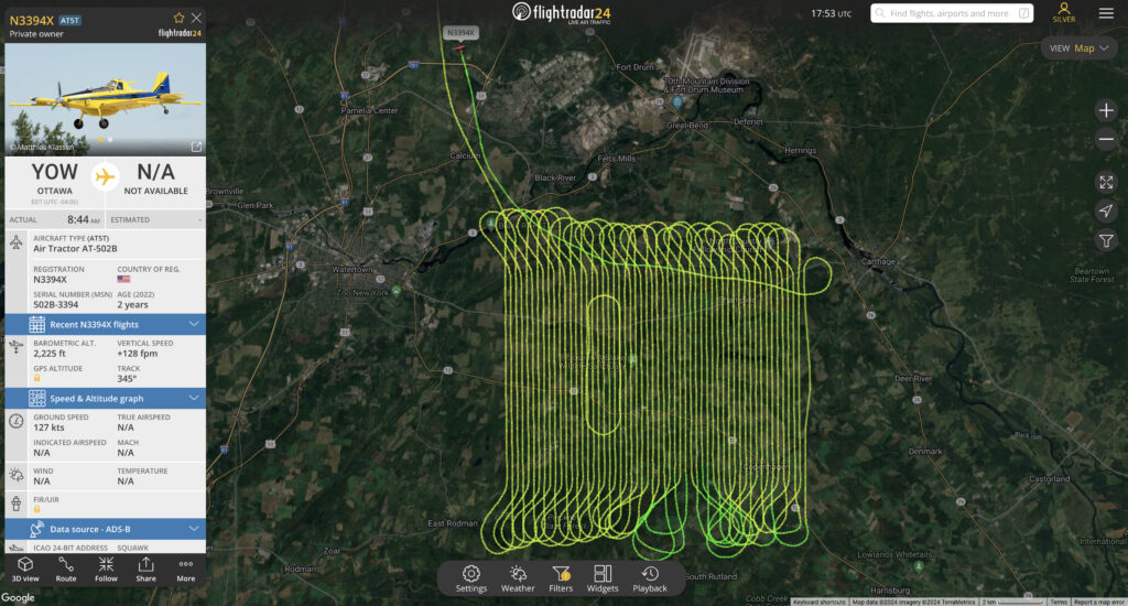
Unidentified Aerial Surveillance: Recurring Air Tractor Activity Over Watertown, NY Raises Security Questions
Incident Overview: For the second time in one week, a U.S.-registered Air Tractor, based out of Ottawa, has been observed operating within the airspace of Metro Watertown, New York. The aircraft is currently engaged in low-altitude scanning south of Fort Drum and west of Watertown, NY. This area is home to military installations and strategic infrastructure, raising the need for close monitoring. Aircraft Details: Model: Air Tractor Base of Operations: Ottawa, Canada Current Activity: Low-altitude aerial surveillance Area of Interest: Location of Surveillance: South of Fort Drum, a key military installation, and west of the city of Watertown, NY. This region houses critical military training and operational grounds, along with civilian infrastructure potentially linked to strategic resources. Timeline: 1st Incident: Occurred earlier in the week, with a similar pattern of flight and scanning behavior. 2nd Incident (Current): The aircraft has returned to the region, following a flight path that suggests focused interest on specific areas adjacent to Fort Drum and Watertown. Possible Objectives: Military Reconnaissance: The proximity to Fort Drum suggests potential intelligence gathering on military activities or equipment. This could involve training exercises, troop movements, or surveillance of restricted airspace. Environmental or Agricultural Monitoring: Given the Air Tractor’s versatility in aerial spraying and environmental surveys, it is possible the aircraft is conducting studies related to agriculture, forestry, or land use in the surrounding area. Border Security and Intrusion Detection: The aircraft’s flight path near the US-Canada border region, including the St. Lawrence River and the 1000 Islands, may indicate cross-border intelligence gathering or anti-smuggling operations. Its frequent return suggests an ongoing operation. Analysis: The recurring presence of the Air Tractor indicates a sustained operation, likely sanctioned by U.S. or Canadian authorities, although its specific mission remains unconfirmed. The aircraft’s scanning pattern, focusing on areas of strategic importance, calls for increased situational awareness. Any unusual or sustained aerial activity over such areas warrants continued monitoring and potential coordination with relevant defense and intelligence agencies. Recommendations: Enhanced Radar Monitoring: Increase surveillance of the area’s airspace to track future occurrences and gather more data on the aircraft’s behavior. Collaboration with Authorities: Engage local and federal agencies to verify the nature of the aircraft’s mission and ensure it aligns with U.S. national security protocols. Public Safety Communications: While no immediate threat is identified, local authorities may want to issue public updates to prevent unnecessary alarm given the unusual frequency of aerial activity. End of report.
Intelligence Analysis Report: Unusual Aircraft Activity Near Fort Drum
Subject: Persistent Surveillance of Fort Drum by Unknown Aircraft
Date: Set 27th 2024
Location: Fort Drum, NY and surrounding area
Observation Summary:
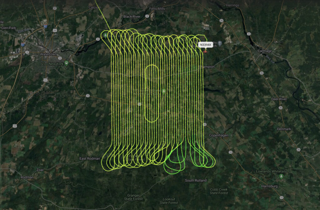
An aircraft, observed over multiple days, appears to be conducting a methodical aerial operation near Fort Drum. Its flight pattern suggests reconnaissance or surveillance activity. Over the past week, the aircraft has been recorded traveling along different perimeters of the base. On the first noted occasion, the aircraft moved along the western boundary of the fort, and most recently, it has focused its flight activity on the southern perimeter. The systematic change in approach direction raises concerns about potential scanning or imaging operations being conducted.
Flight Pattern Analysis:
The aircraft’s movements indicate a strategic approach. Last week, it conducted a northern-to-southern sweep along the west side of Fort Drum, maintaining consistent altitudes and speeds typically associated with intelligence-gathering flights. This week, it shifted its focus to the southern side, exhibiting similar characteristics. The aircraft’s behavior suggests a pattern of encirclement, with each pass possibly providing a different angle for capturing detailed real-time imagery or data.
Assessment:
The flight pattern is consistent with ISR (Intelligence, Surveillance, and Reconnaissance) operations, which typically seek to build a comprehensive picture of a target’s geography, assets, or activity. The consistent encircling and the variety of directional approaches strongly indicate that the aircraft may be conducting various forms of reconnaissance, such as multi-sensor scanning (thermal, infrared, or SAR radar) of Fort Drum.
Potential Implications:
- Aerial Surveillance: The aircraft’s movements suggest it could be collecting imagery for intelligence purposes, such as mapping out key infrastructure or monitoring troop movements within Fort Drum.
- Electronic Warfare Potential: There’s also the possibility of signal intelligence (SIGINT) or other forms of electronic data collection, which could be concerning given Fort Drum’s strategic importance.
- Strategic Realignment: The shift in flight activity from west to south could indicate a gradual attempt to complete a full perimeter sweep, potentially to cover all entry points or vulnerable areas of the base.
Recommendations:
- Airspace Monitoring: Increased surveillance of flight paths in the Fort Drum region is recommended. Capturing real-time aircraft tracking and photographic evidence from these positions would provide further insight into the operation’s intent.
- Coordination with Fort Drum Command: Intelligence personnel at Fort Drum should be alerted to the activity for immediate review and analysis, particularly if this aircraft has not filed flight plans or has suspicious affiliations.
- Further Investigation: It’s critical to assess whether this aircraft has been involved in other aerial missions near military installations in the region, potentially indicating a broader reconnaissance effort.
Mystery in the Skies: Unidentified Aircraft’s Covert Maneuvers Across the Ottawa-NY Border
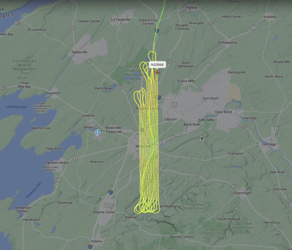
Subject: Analysis of Unusual Aircraft Activity in the Ottawa-NY Border Region Summary: An unidentified aircraft departed from Ottawa, Canada, and proceeded southward towards the USA/New York border. Upon approaching the 1000 Islands region, the aircraft turned off its transponder, subsequently crossing the St. Lawrence River. The transponder was reactivated shortly after, and the aircraft continued south, descending from an altitude of 3,000 feet to approximately 350 feet. The aircraft then executed a U-turn near Adams Center, NY, and landed in a field in Honeyville, NY, where it remained for approximately three minutes. Following this brief stop, the aircraft took off, heading back north towards Canada. Upon reaching the border, the transponder was again deactivated. The aircraft then encountered a Canadian government aircraft, prompting a hard right turn, ensuring it remained within U.S. airspace. The aircraft continued towards Massena, NY, where the transponder was once again deactivated, and the aircraft headed towards the Adirondack Mountains. Assessment: The sequence of events, including the multiple transponder deactivations, the brief landing in a remote area, and the evasion of a Canadian government aircraft, suggest suspicious activity. Possible scenarios include smuggling operations, covert surveillance, or unauthorized operations in the border region. Further investigation and coordination with both Canadian and U.S. authorities are recommended to ascertain the intent and origins of this aircraft.
09/24/2024 Possible Surveillance, Reconnaissance, or Covert Ops Over Watertown and Northern NY
Analyst assessing the situation described, involving a U.S.-registered Air Tractor flying a specific low-altitude route from Ottawa, Canada, into the U.S. over the St. Lawrence River and looping over Watertown, Adams Center, and Rodman, several potential scenarios come to mind: Surveillance or Reconnaissance Operations: The low-altitude flight pattern and repeated passes over the area could suggest the aircraft is engaged in surveillance. This could be related to border security, monitoring of agricultural or environmental conditions, or more covert reconnaissance activity. The proximity to Watertown and its surrounding areas might indicate an interest in critical infrastructure or local activities of strategic interest. Agricultural or Environmental Monitoring: Air Tractors are commonly used for crop-dusting or environmental monitoring. It’s possible that this aircraft is engaged in some kind of environmental survey or agricultural operation, though the international flight path complicates this interpretation. The specific locations and the low altitude suggest precise monitoring or spraying operations. Training or Calibration Flights: Another plausible explanation could be that the Air Tractor is conducting training exercises, equipment testing, or calibration for sensors or other airborne instruments. The repeated low-altitude passes could indicate practice runs or equipment calibration that requires specific altitude and terrain conditions. Law Enforcement or Customs Operations: Given that the aircraft crosses the U.S.-Canada border, it’s possible that it is being used in coordination with U.S. Customs and Border Protection or another agency tasked with monitoring cross-border activities. Low-altitude flights may enhance visual identification of vehicles, people, or shipments moving across the region. Covert Operations or Suspicious Activity: The unusual flight pattern, crossing from Canada into the U.S., may raise red flags, especially if it’s occurring without prior authorization or notice. The aircraft’s low altitude could be an attempt to evade radar detection, potentially pointing to smuggling or other illicit activities. A thorough investigation into the aircraft’s registration, flight plan, and any observed behaviors would be critical in determining if there’s any potential threat. Recommendations: Verify the Aircraft’s Registration: Cross-check the U.S. registration of the Air Tractor and confirm whether it is operating with proper permissions for both Canadian and U.S. airspace. Coordinate with Border Security: Alert U.S. Customs and Border Protection and relevant Canadian authorities to ensure this isn’t part of a sanctioned operation and rule out illicit cross-border activity. Monitor Future Flights: If this pattern continues, increased surveillance might be necessary to determine the purpose of these repeated flights. A comprehensive analysis would depend on further data collection, including flight logs, registration details, and communication with local agencies.